Storm Ragasa strengthens into super typhoon near Philippines

By Gia Chinh   September 21, 2025 | 07:01 am PT
Storm Ragasa intensified into a super typhoon with winds above 200 km per hour east of Luzon Island, Philippines, on Sunday night, two days after it was formed from a tropical depression.

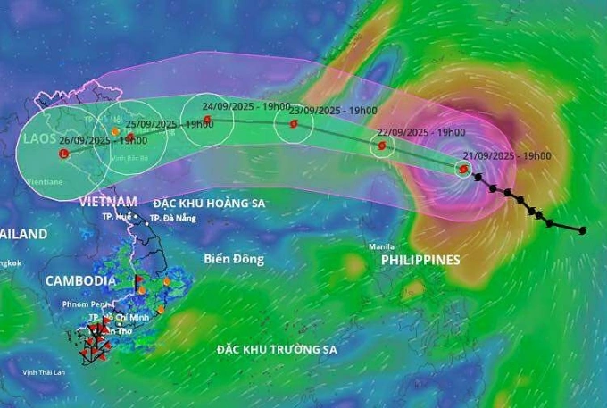
Vietnam's National Center for Hydro-Meteorological Forecasting said that at 7 p.m. the storm was about 350 km east of Luzon, with maximum sustained winds of 221 kph. It was moving northwest at 15–20 kph and, by 7 p.m. Monday, is expected to be about 120 km from Luzon with winds of up to 220 kph.

By 7 p.m. on Tuesday, the super typhoon is forecast to be over the northern East Sea (South China Sea), with peak winds of 184–220 kph. A day later, it is expected to be in waters off China's Guangdong Province, weakening to 150–183 kph and showing a further weakening trend.

Under the storm's influence, the eastern sector of the northern East Sea will see strong winds from Sept. 22 and waves over 10 meters. Vessels operating in this dangerous area are likely to be affected.

Dự báo đường đi và khu vực ảnh hưởng của bão. Ảnh: Hệ thống cảnh báo thiên tai

The forecast trajectory of Super Typhoon Ragasa. Photo by Vietnam Disaster Monitoring System

Hoang Phuc Lam, deputy director of the National Center for Hydro-Meteorological Forecasting, said the storm will be strongest on Monday and Tuesday. The Japan Meteorological Agency puts the potential peak near 195 kph; the China Meteorological Administration, around 223 kph; and the Hong Kong Observatory, up to 240 kph.

Two possible tracks

Lam outlined two scenarios for Ragasa's path. In the first, as the storm reaches seas south of Guangdong on Wednesday, land interaction causes it to weaken, with further weakening as it enters the Gulf of Tonkin. In the second, the worst-case scenario, Ragasa moves mainly westward across the East Sea and is less likely to weaken. In that case, Vietnam’s northern and north-central coasts could experience very strong winds and heavy rain.

A cold air mass currently over northern Vietnam could also interact with the storm and complicate conditions, Lam added. "It is necessary to continue updating forecasts based on monitoring data and subsequent analysis," he said.

So far this year, the South China Sea has seen eight storms and two tropical depressions. Most recently, Storm Mitag struck China on Saturday without directly affecting Vietnam. The seventh storm, Tapah, did not make landfall in Vietnam but brought heavy rain and landslides to northern mountainous provinces earlier this month. On Aug. 30, Storm Nongfa hit central Vietnam with winds of 62–74 kph, cutting off mountain communities in Ha Tinh, Quang Tri, and Nghe An.

Meteorologists warn that from October to December the basin could see more storms than average, with more than four likely in the final quarter, nearly half of which may make landfall.

In 2024, the Northwest Pacific recorded three super typhoons, defined as carrying maximum winds of 201 kph: Yagi, Gaemi, and Krathon. Yagi made landfall in Vietnam in September, triggering landslides, flash floods, and inundation that killed 318 people, left 26 missing, and caused an estimated VND84 trillion (US$3.18 billion) in economic damage.


go to top