The most read Vietnamese newspaper
Edition: International | Vietnamese
© Copyright 1997 VnExpress.net. All rights reserved.
In recent days a bout of record-high tides has caused widespread flooding.
Low-lying areas in the former District 7 and Binh Chanh District, including Tran Xuan Soan, Pham Huu Lau and Le Van Luong streets, and National Highway 50, were under more than half a meter of water.
Thanh Da Peninsula (in the former Binh Thanh District) and Thao Dien (in Thu Duc City) on the eastern gateway have been other spots to suffer, with large swathes underwater and traffic disrupted.
Rising tides on the Saigon River overflowed the embankment, causing flooding in the Thanh Da area, Oct. 25, 2025. Video by Tuan Viet, Minh Hoang
Thanh Da Peninsula, surrounded by the Saigon River on three sides, has been hit the hardest.
For three days from Oct. 23 to 25 the Thanh Da Apartment Building was under more than half a meter of water.
People tried to block the water with sandbags and makeshift barriers but to no avail.
Several restaurants at the Binh Quoi tourism site had their riverside walls collapsing and were under more than a meter of water.
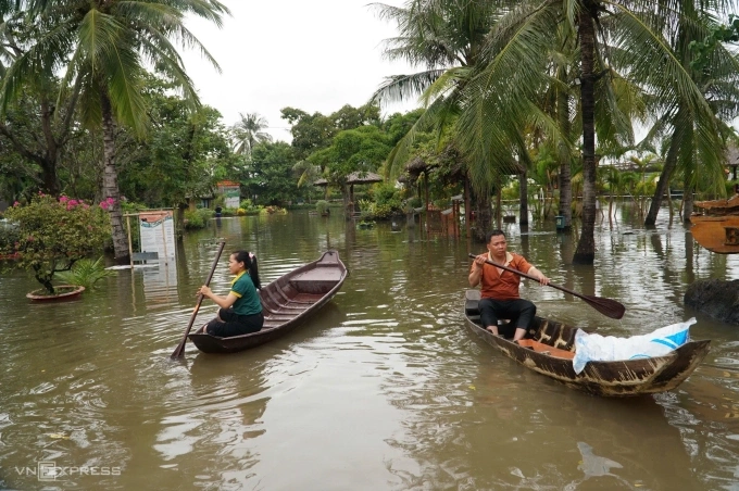 |
|
Binh Quoi tourist area in HCMC is deeply flooded, forcing staff to row boats to get around, Oct. 25, 2025. Photo by VnExpress/Quynh Tran |
On Oct. 25, when the tide peaked and heavy rains fell simultaneously, floodwaters rushed into the home of Nguyen Thi Ngoc Diep on Binh Quoi Street in the namesake ward.
Within 15 minutes the water rose high enough to submerge cabinets, furniture and electrical appliances.
The family only had enough time to move their motorbikes to higher ground, leaving less wieldy stuff behind.
The situation worsened when the wall of a riverside restaurant across the street broke, sending torrents of water into the residential area.
"I've lived here for nearly 30 years, but this is the first time I've seen the tide rise this fast," Diep said.
Though she has raised her house foundation and installed a water pump, the tide was too high this time for her family to handle.
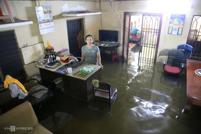 |
|
Nguyen Thi Ngoc Diep stands in her living room on Binh Quoi Street, HCMC, which was flooded by nearly half a meter of water during a high tide on Oct. 25, 2025. Photo by VnExpress/Dinh Van |
Le Dinh Quyet, head of the forecasting division at the Southern and Central Highlands Hydro-Meteorological Station, said the tides reached their highest levels in the Saigon River in many years.
At Phu An Station in the city's downtown area, the water level reached 1.77 meters, matching the 2019 record, while at Nha Be Station in the southern gateway, it rose to 1.78 meters, the highest in seven years.
In the last 25 years, the peak tide at these two stations has risen by 31–38 cm.
According to the city Department of Agriculture and Environment, water levels in the Saigon River were "extremely high", especially on Oct. 23 and 24.
At Thu Dau Mot Station in the former Binh Duong Province, the water level reached 1.87 m, much higher than average.
An irrigation official from the Ministry of Agriculture and Environment said things were aggravated by discharges from the Tri An and Dau Tieng hydropower reservoirs in neighboring Dong Nai and Tay Ninh provinces.
While the releases were necessary for dam safety, their timing coincided with the tide peak, a critical obstacle in flood management, leading to widespread flooding in HCMC, the official, who asked not to be identified, said.
The city’s flood control capacity is constrained by a deteriorating drainage system and delays in several major projects, he said.
"Not to mention that HCMC is facing severe land subsidence caused by rapid urbanization and excessive groundwater extraction."
Citing data from 24 monitoring sites published by the Ministry of Agriculture and Rural Development's water resources management department, he said that between 2009 and 2019, the city's average subsidence rate was around four centimeters per year, and the phenomenon has not ceased.
As the city sinks while sea levels and tides continue to rise, flooding is becoming increasingly severe, especially along rivers and in low-lying areas.
Assoc. Prof. Dr. Le Trung Chon, director of the Research Institute for Sustainable Development at the University of Natural Resources and Environment HCMC, cited research showing that Ho Chi Minh City is sinking by an average of 2–5 cm per year, with some commercial areas going down by up to 8 cm.
This is one of the key reasons for the worsening flooding.
Chon said subsidence is occurring across large swathes of the city, particularly along the Saigon River on the northwest–southeast axis and in the former Districts 7 and 8.
Satellite data clearly indicates significant sinking in these areas, he said.
"Subsidence greatly increases flood risk, especially when combined with climate change and sea-level rise. It also damages transport and drainage infrastructure and buildings."
Current technology allows for precise monitoring of subsidence rates, he said.
He said the city should treat this as a critical data input in its urban planning and as a basis for infrastructure design, construction and maintenance.
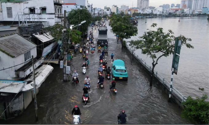 |
|
Heavy rain and rising tides caused about 2 km of Tran Xuan Soan Street in HCMC to be flooded on Oct. 17, 2025. Photo by VnExpress/Gia Minh |
To cope with tidal flooding, the Department of Agriculture and Environment said it has instructed related agencies to strengthen disaster-prevention measures in critical areas, including the speeding up of urgent hydraulic projects, such as upgrading the right bank of the Saigon River, reinforcing its embankment from Tra Canal to the Vam Thuat River, a tributary, and preventing erosion on Thanh Da Peninsula.
One project the city places high hopes on is the VND10 trillion (US$390 million) anti-flooding project it launched in 2016.
Originally planned for completion in two years, it seeks to control tidal flooding and respond to climate change across 570 square kilometers, benefiting 6.5 million residents along the Saigon River and elsewhere in the city.
Despite being 90% complete, the project has been stalled for long due to legal and land payment issues.
Recently, the working group tasked by the government with resolving the difficulties proposed adding two more land plots to the payment to be made to the investor.
The investor, HCMC-based Trung Nam BT 1547 Co. Ltd., has consented and said if the procedures are completed by the end of this month, the work could be completed by December 2026 at the latest.
When that happens, the long-suffering flooding hotspots in the southern gateway of the city, including Huynh Tan Phat, Tran Xuan Soan, and Le Van Luong streets and National Highway 50, will finally heave a sigh of relief.


