Typhoon Matmo heads for Vietnam–China border, may dump 400 mm of rain over two days

By Gia Chinh   October 5, 2025 | 03:48 am PT
Typhoon Matmo is forecast to enter the Gulf of Tonkin Sunday night, then track along the Vietnam–China border with sustained winds around 62–88 kilometers per hour, bringing heavy rain to northern midland and mountainous areas, with some locations exceeding 400 mm over two days.

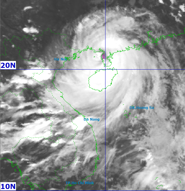
Matmo lay centered over China's Leizhou Peninsula, about 210 km from Mong Cai of Vietnam's Quang Ninh Province, at 5 p.m. Sunday, with maximum sustained winds near 133 kph, according to the National Center for Hydro-Meteorological Forecasting. Terrain friction after lashing China's southern coast has weakened the storm slightly from Sunday morning.

Maintaining a west-northwest track at about 20 kph, the storm is expected to move over the Gulf of Tonkin in the coming hours and reach Guangxi Province's mainland by around 4 a.m. Monday with sustained winds around 62–88 kph. It will then skirt the Vietnam–China border, weakening to a tropical depression and later a low-pressure area over the northern mountains.

Japan Meteorological Agency estimates Matmo's sustained winds at 126 kph, easing to about 90 kph near landfall on the Vietnam–China border. Hong Kong Observatory expects it to weaken to a tropical depression over Vietnam's Cao Bang Province which borders China.

Mai Van Khiem, director of Vietnam's national forecasting center, said the storm’s circulation is relatively broad, so strong winds on land are likely from Sunday night through midday Monday. In addition to wind, authorities and residents should prepare for heavy rain, especially in the northern midlands and mountains.

There is also high risk of flash floods and landslides. During Typhoon Bualoi, heavy rain saturated soils across the northern midlands and mountains, and multiple landslides were recorded.

"With Matmo's rain, the risk of landslides and flash floods in the midlands and mountains is very high," Khiem warned, urging localities to review and evacuate vulnerable areas.

Ảnh vệ tinh bão lúc 17h ngày 5/10. Ảnh: NCHMF

Satellite image of Typhoon Matmo at 5 p.m. on Oct. 5, 2025. Photo courtesy of the National Center for Hydro-Meteorological Forecasting

Mountainous midlands could see over 400 mm rainfall

From Sunday night through Tuesday night, the northern midlands and mountains are expected to receive 150–250 mm of rain, with some spots over 400 mm; downpours could exceed 150 mm in three hours.

The northern Delta and Thanh Hoa Province may see 70–150 mm, locally over 200 mm.

Hanoi is unlikely to face the storm’s core impacts, but thunderstorms, tornadoes, and strong gusts are possible. From early Monday through Tuesday, the capital city may receive 70–120 mm rainfall, locally 150+ mm—much less than during Typhoon Bualoi, when Hanoi Drainage Company reported inner-city total rainfall from 120 mm to more than 600 mm over two days of Sept. 29 and 30, causing 116 flood points, typically 0.3–0.5 m deep and in some places 1–1.5 m.

Gulf of Tonkin winds

Over the Gulf of Tonkin, sustained winds are forecast to increase from about 62 to 117 kph, with gusts up to roughly 150–166 kph. Significant wave heights may reach 4–6 m, and 6–8 m near the storm center.

In the northern Gulf of Tonkin, including Bach Long Vy, Van Don, Co To, Cat Hai and Hon Dau islands, sustained winds are expected to rise from about 39 to 133 kph, with gusts up to roughly 167–183 km/h (around Beaufort 15).

Waves may reach 2–4 m, and 3–5 m near the center. Coastal areas and islands in Quang Ninh–Hai Phong could see storm surges of 0.4–0.6 m; low-lying shores and river mouths face flood risk from the combination of surge and large waves from Sunday evening.

Inland winds

From Sunday to Monday afternoon, coastal districts from Quang Ninh to Hung Yen and in Lang Son may see sustained winds rising from about 39 to 88 kph, with gusts up to 112 kph. Farther inland in the northeast, sustained winds may reach 20–49 kph, with gusts up to 74 kph.

Communes in northeastern Quang Ninh could experience sustained winds around 75–102 kph, with gusts from 118 to roughly 149 kph. Elsewhere, including the Hai Phong coast, sustained winds around 62–88 kph with gusts 89–117 kph are possible. The coastal area of Hung Yen and northern border communes of Lang Son may see 39–74 kph winds, gusting 75–102 kph.

Northeastern Bac Ninh (formerly part of Bac Giang) and eastern Cao Bang may experience around 39–49 kph winds with gusts up to 62–74 kph.

To cope with the storm, Hanoi has allowed 2.3 million students from kindergartens to high schools to stay home Monday, and advised companies to switch to work-from-home mode.


go to top